

It is no secret that flying a drone in the United States keeps getting more and more complicated. And even looking at the best LAANC apps doesn’t make things seem any less complicated.
In fact, the FAA just announced that all drone pilots will soon be required to take a written exam of some kind (check out my article on new recreational drone rules). And while we don’t know what this test will look like yet, it already means that recreational drone pilots can only fly at specific flying sites when in controlled airspace or use LAANC (link to article on using LAANC) to get approval to fly in controlled airspace.
Finding and Understanding the Best LAANC Apps
Naturally, I think some people are concerned that this will dampen enthusiasm for the hobby. And while that may be the case, we have to follow the rules. Sometimes though, the question is something more like, how the heck am I supposed to know where I can fly? Especially when you pull up the Know Before You Fly site and see this.
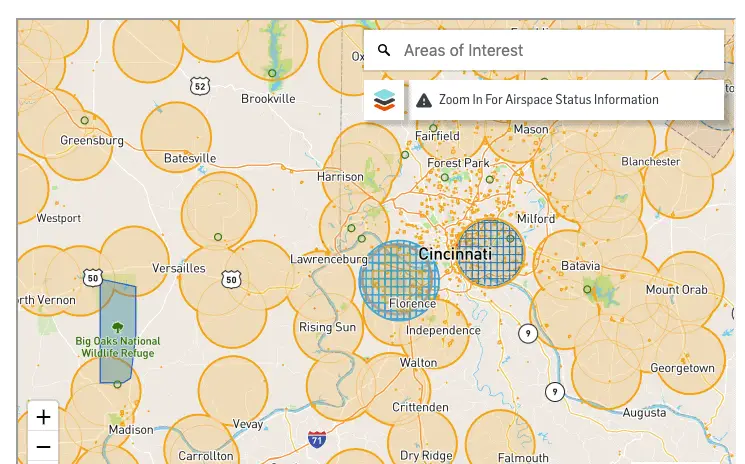
To a newbie, this map could look like you’re only allowed to take your drone out into the boonies to fly. And while that’s not exactly the case, understanding what you’re seeing is pretty important.
So, what are the best LAANC apps?
The Know Before You Fly is typically the first thing that will come up if you do a quick Google search but this doesn’t mean that it is the best LAANC app available. Know Before You Fly pulls its information from a drone flight map app called Airmap. But Know Before You Fly also just partnered with Kittyhawk (another airspace map tool) to create another app. In my opinion, Kittyhawk is the best LAANC app, hands down. But to be fair, it comes with a little bit of a learning curve because the user interface has so many features packed into it.
So, I’m going to answer a few basic questions about using these apps up front and then I’ll talk details about the features of Kittyhawk, Airmap and the Know Before You Fly app. That way, you can choose the best LAANC apps for yourself and go from there. Links to all apps for Google Play and App Store are below. Be forewarned, I don’t recommend downloading B4UFLY for the reasons I discuss below. Airmap and Kittyhawk are both much more helpful.
Download the Airmap App
|
Download the Kittyhawk App
|
Download the Know Before You Fly App
|

How can I tell if I’m allowed to fly my drone using LAANC apps?
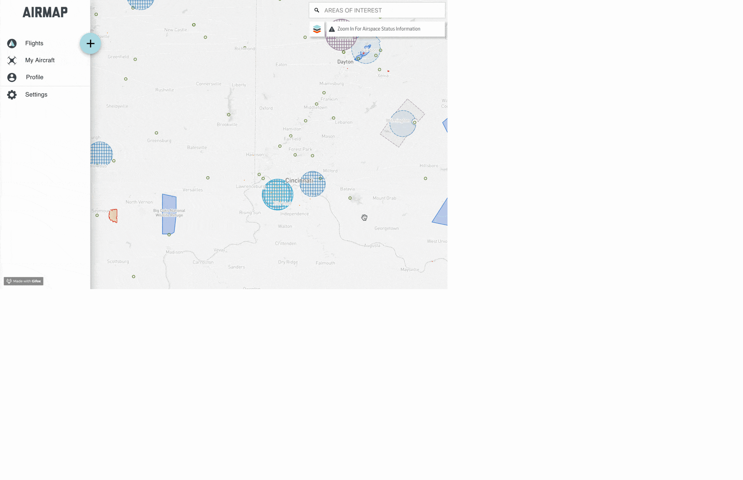
Being able to tell what kind of airspace you’re in is pretty much the same on Airmap, Kittyhawk and B4UFLY. I’ll use screen shots from Airmap below, but just know that the interface for the actual airspace looks similar on each of the apps. Once you’re logged in, you’re able to see the menu on the left-hand side of the screen in the picture below. Clicking on any of these icons allows you to see a more detailed menu. So every flight I’ve ever logged through Airmap is pulled up when I click flights. And all of my registered drones are listed under “My Aircraft.” The reason you should create an account is that this allows your information to be synced across all devices. I don’t know about you but I don’t usually have my computer out when I’m flying. But my iPhone or iPad are usually close at hand (as in literally in my hands).
If you look to the right hand side of the screen, you’ll see that you can choose the types of rules you want to use. There’s still an option for commercial drone pilots operating under a 333 Exemption, but at this point you will either want to choose recreational rules or Part 107 rules.
Do I have to use a LAANC app?
You don’t have to, but these days it is a terrible idea to fly your drone without at least consulting one. Obviously, as a Part 107 drone pilot, you are required to be aware of the airspace conditions around you. And as a recreational drone pilot, with access to LAANC authorizations, you’re not really in a position to ignore airspace anymore either. The continued regulation of flying drones means that the responsibility is increasingly on the pilot. And this is where the responsibility should be. As must as I hate things to be over-regulated, I think some recreational drone pilots forget that they are flying in the National Airspace System, with manned aircraft. That’s a pretty solid responsibility. The least you can do is open an app on your phone to make sure you’re not putting anyone in danger.
Which brings me to the next section of this article.
What is the best LAANC app for a drone pilot to use?
Here’s my answer: if you’re a recreational drone pilot, use Airmap. If you are a Part 107 drone pilot, use Kittyhawk. The reason for this split is that Airmap has a really straightforward user interface. But because of this simplicity, it lacks some additional features that are great for Part 107 drone pilots. Kittyhawk, on the other hand, comes with a bit of a learning curve, due to all of the features that are packed into the app. If you want some more insight into using each app, keep reading.
Airmap Review
Like I said before Airmap is really great at getting LAANC approval. If that’s all you need to do, this app is perfect. The process to get LAANC authorization takes about 30 seconds, no joke. Logging in is made really easy because you can use single sign-on with your Google account. I know I’m helping Google take over the world, but who has room in their head for another password? Maybe I’ll change my tune when Google builds Skynet.
Uh, just kidding…
Anyway, Airmap lets you get drone insurance on the fly when you are getting airspace approval and you can even fly certain DJI drones without ever leaving the app. At this point, even though there is a record of your flights kept inside the app, there doesn’t appear to be a way to download or export this information. And while you can actually just use this app to track all of your drone flights even if they don’t require LAANC approval, because you can’t download or export this information. If this is your plan, I’d use Kittyhawk instead.
Pros:
- Straightforward user interface for really simple LAANC authorization
- It uses Google Single Sign-on
- Allows for in flight drone control without leaving app
- Drone insurance option built in
- Provides record of previous and current flights (including authorization) in app
- Saves pilot and drone information for future use
- Basic weather on dashboard
Cons:
- Features not as robust as Kittyhawk
- Flight data is not integrated or downloadable from DJI
Kittyhawk Review
Because of the number of features in Kittyhawk, this has become my go-to LAANC app. But it does so much more than just providing LAANC approval. These guys have thought of it all because they are actually drone pilots. Here’s a really great podcast that I listened to with the founders of Kittyhawk.
As someone that is also an iPhone user and a general technology geek, the first thing I appreciate about Kittyhawk isthe fact that you can login with FaceID. If you can’t tell, I hate remembering logins and by using my face, I don’t have to remember this one. Once you login though, it provides a really in-depth dashboard with everything from weather, KP index, GPS signal, cloud cover, temp, humidity, wind (including gusts) and even sunset time.
The map, which is on the top half of the dashboard, very clearly shows where you can get LAANC approval, with green, yellow and red boxes corresponding with the FAA’s own grid map. One thing I don’t like about Kittyhawk’s map is that while is shows where you can get LAANC approval, it doesn’t do a very good job showing you the altitude at which you can get automatic approval. In Airmap, I’m able to zoom in and see the altitude that the FAA has set for LAANC approval. This is’t shown on Kittyhawk.
The other thing that is kind of difficult to understand on Kittyhawk is what the other markings on the map mean. In Airmap, I’m able to drop a pin in the app at a given location and it gives me all of the restrictions for my flight area. Below are a couple of screen shots in Airmap to show you what I mean.
Airmap Screenshots:
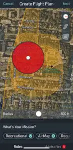
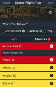
You can see that I’ve placed my location in a small National Park near Cincinnati. When I scroll up for the airspace restrictions in this area, it tells me that I’m looking to fly in a National Park (check out my article on flying in National Parks and Monuments here) as well as near a prison, airport, hospital and school. All of this information is super helpful, especially if there is an airspace restriction you are unsure of.
In Kittyhawk, there’s no way to click on a specific airspace restriction and figure out what it is. Going to the same place on the map as I did above in Airmap, it just says “Historic Site,” I can’t physically click the map or move my location here to determine what the restriction actually is. It’s entirely possible that I’m missing this feature but here’s the thing, if I can’t figure out how to get this information, I’m probably not the only one having this problem and it’s a user interface issue that needs to be fixed.
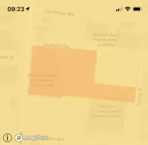
This picture is the same for the overlying orange airspace restriction. It’s not in controlled airspace, but I can’t tell what the orange means. This would be a really easy fix and again, knowing about each restriction is super helpful. I’m not sure why Kittyhawk doesn’t provide this information but they aren’t setting themselves up for widespread use if a novice drone pilot isn’t able to open the map and understand what they’re looking at.
Despite my complaints about providing details on airspace restrictions, I’d still recommend Kittyhawk for Part 107 drone pilots because it allows you to go through an entire workflow without ever leaving the app. You can create missions (and even create them in advance), create and log use of custom checklists, see other drone traffic, get LAANC approval, log a risk assessment. and track maintenance. Each of these activities can be associated to one another providing the ability to handle all of your information in one place.
You can also create assets, including drones and batteries and log the use of these on each flight as well. Kittyhawk also has a web app where you can seamlessly access everything just like you can from the iPhone app. Kittyhawk even allows you to sync (and export) your flight information if you use the DJI Go app to fly. If you’re interested in more information on logging your drone flights, check out my article on why you should be keeping a drone logbook.
Like I said before, despite the oversight on the map interface issue, this app really does provide a one-stop shop for drone pilots.
Pros:
- Uses Face ID on iPhone for level of security.
- Detailed weather on dashboard including
- Provides myriad of other features including linking up flights to various missions, drones, checklists, risk assessments and authorizations.
- Shows other Kittyhawk flights on map
- Allows for in flight drone control without leaving app
- Syncs to DJI Go
- Allows exporting of flight information
Cons:
- Map interface doesn’t provide details airspace restriction information like Airmap.
- Extra info on screen may be overwhelming for a new drone pilot or someone that just wants to get a LAANC authorization to fly their drone for fun.
B4UFLY
This app has the basic features you’d be looking for to determine if you just want to know what the airspace around you is like. This would include TFRs, helipads, stadiums, as well as just controlled airspace or small airports without controlled airspace around them.
But honestly, it’s not really worth downloading and here’s why. Under current FAA rules, any drone flight that occurs in controlled airspace needs to be approved. This is now true for recreational and Part 107 drone pilots. (Check out my article on getting LAANC Approval for waivers ad authorizations). No more calling the control tower for approval, etc. So if you’re using a drone airspace map tool, you need it to be able to request LAANC authorization for you. The B4UFLY app doesn’t do that.
In fact, if you use their side panel to “Get LAANC,” it is just going to direct you to the App Store to download Kittyhawk. You may as well skip this app and directly download Kittyhawk or Airmap. Honestly, I’m not really sure why they created this app other than to use it as a tool to get more users on Kittyhawk. But that’s fine, because the more users understand how to get authorizations, the safe drone flights will be all around.