

Today we take a good look at the identification of airports on a sectional chart. You may be wondering how this is different from just identifying airspace, and that’s a fair question. But did you know that there are airports that are small enough that they don’t have their own airspace around them? As a manned pilot, this became clear to me as soon as I began flying. Even now, I often make the trip between Cincinnati and Columbus and there is a small grass airstrip that runs along the interstate. I’ve yet to see a plane actually taking off but it is there. As a commercial drone pilot, at some point you will be flying in an area that is close to one of these airports. So it is important to be able to understand the identification of airports.
Here’s the question:
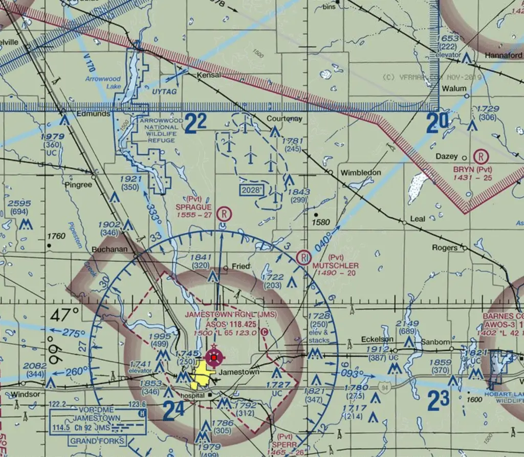
(Refer to figure 26, area 3) You have been asked to fly a tower inspection mission just south of Courtenay, North Dakota (area 3).You are not in the airspace for Jamestown Regional (JMS) airport Are there any airports or controlled airspace that requires an authorization prior to flight?
- There are no airports within five miles of your mission
- There is one private airport within five miles of your mission that is surrounded by Class E airspace.
- There is one private airport within five miles of your mission but it does not have any controlled airspace surrounding it.
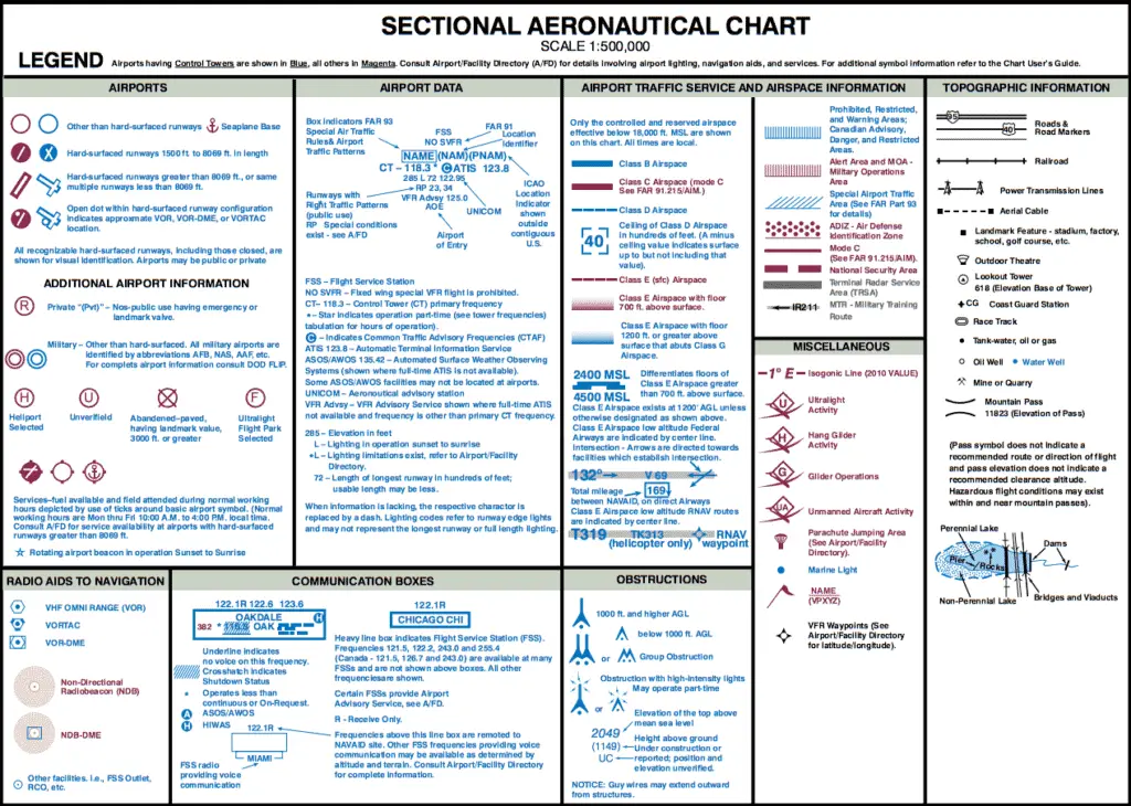
Like I always do on sectional chart questions, I’m first going to point you to the sectional legend. (Also, check out our article on how to read a sectional). We need to compare the symbols in the area we’re looking at against the sectional legend. First, there is an obstruction just North of Courtenay with a height of 1,781 feet MSL.
Just South of Courtenay, it looks like there is an obstruction with an elevation of 1,843 feet MSL. That might be the tower we’ve been hired to inspect. Looking even a bit further South, we can see that there’s an “R” in a magenta circle and next to it the words “(Pvt) SPRAGUE.”
Identification of Airports
The sectional legend has a whole portion to the left that deal with airport symbols. The “R” in a circle means “Private ’(Pvt)’ – Non-public use having emergency or landmark value.” So this looks like a private airport, which means that answer A is incorrect, as there is an airport within 5 miles of your mission.
Next, you’ll notice that the top of the sectional legend tells us that “Airports having Control Towers are shown in Blue, all others in Magenta.” Since the “R” in a circle is magenta, we know that this private airport does not have a control tower. But if we go back to the sectional itself, we should notice that there is no outline, either faded or dashed. All of this together can be taken to mean that there is no controlled airspace surrounding the Sprague airport. This means that answer B is incorrect.
Obviously then, this leaves answer C. But let’s talk for a second about why this is correct instead of why it is incorrect. Remember that Class G is the only type of uncontrolled airspace and because it is so prevalent, it is not depicted on sectional maps. If it were, we would end of with a map that was covered in whatever color was used to depict Class G airspace. Instead, we know Class G airspace is there based on the absence of other types of airspace. If there is not a faded or dashed ring or outline surrounding an area, we know it is not controlled airspace. If there is no set of outlines with perpendicular lines extending from it, we know that there is no type of special airspace restriction or usage surrounding this area. Class G is always shown on a sectional by the absence of another type of airspace.
So in our example, although there is an airport within five miles of your mission, there is no need to get an airspace authorization because you will be flying in Class G airspace. Now, to be clear, you should be aware of this airport and you should fly in a way that is extra cautious because the fact remains that airplanes do fly in and out of this airport, even if it is not extremely busy. It might even be worth a call to the airport if you are able to find a phone number or contact info.
While you might have a hard time finding this for most private airports, it is possible. Here, I just Googled the Sprague airport and came up with all of the information I could want. This page includes the phone number of the owner as well as runway info. Even if you can’t get a hold of the owner, you can know that the runway is essentially running North/South, so that helps you understand the traffic patterns and where you could expect planes to be flying.
If you’ve made it this far and this article was helpful to you, I put out new content all the time and would love to be invited into your inbox. I hate emails that clutter my inbox, so I won’t clutter yours. Just helpful information about flying your drone legally. Sign up below if you’re interested or check out our Ultimate Part 107 Study Guide.