

Have you ever been confused by the jumble of numbers and letters that show up next to an airport on a sectional chart? I know that the identification of radio frequencies can be a tough concept to master for the Part 107 exam and that’s why we’re covering it in today’s FAA Part 107 test question.
Here’s the question:
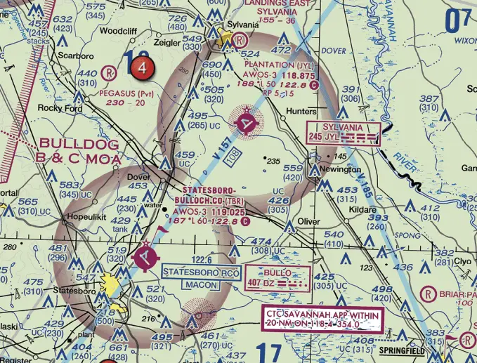
In the sectional chart below, what is the radio frequency used at Statesboro Bulloch Co. (TBR) as the Common Traffic Advisory Frequency (CTAF)?
- 122.8
- 118.875
- 119.025
As I’ll always tells you, when you get a sectional chart question on the Part 107 exam, the first thing you should do is take a look at the sectional chart legend. It ALWAYS has something to say that is helpful, and sometimes it will even straight up give you the answer.
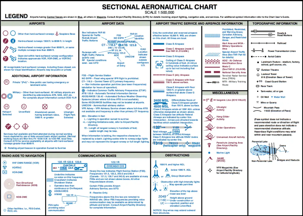
Here we’re focusing on the section of the legend called “Airport Data. ” You should notice that the block of text at the top looks similar to the one we are focusing on for the Statesboro airport in our question. If you look at the legend though, it provides three different radio frequencies, while the Statesboro airport only shows two radio frequencies.
Part of what is important with the identification of radio frequencies is their location in this block. As you can see in the sectional legend, UNICOM is going to show up at the end of the second line after the airport elevation, lighting and runway numbers. In the legend, UNICOM is “122.95.” What can sometimes be confusing is that UNICOM and CTAF can be the same frequency but they don’t have to be.
To identify the correct CTAF radio frequency, you’re looking for the C in a circle. In the sectional legend, you’ll notice the C in a circle is next to the ATIS frequency of “123.8.” So, the sectional legend is saying that 123.8 is used for ATIS (recorded airport information) as well as CTAF. Just to be clear, the color of the text will always match the type of airspace. In the sectional legend, it is blue, but it could also be magenta if the airport is Class C or Class E airspace.
RELATED: Radio communications for Drone Pilots
Let’s go back to our question. At the Statesboro airport, the C in a circle is next to the frequency “122.8,” which means that this frequency is the CTAF. Remember though, when the radio frequency is in this spot (end of the second line) the sectional legend tells us it is also the UNICOM station.
Just to cover the other answers though, 119.025 is another radio frequency for the Statesboro airport but it looks like this is the AWOS (weather station). And while 118.875 doesn’t show up next to the Statesboro airport, it is the AWOS for the Plantation (JYL) airport to the Northeast of the Statesboro airport.
If you’ve made it this far and this article was helpful to you, I put out new content all the time and would love to be invited into your inbox. I hate emails that clutter my inbox, so I won’t clutter yours. Just helpful information about flying your drone legally. Sign up below if you’re interested.