

Today we are looking at another Part 107 video test prep question. This one will teach you how to read TAFs and METARs. Here I’m going to walk through a specific TAF, but also walk through a specific question as well. If you’re looking for a more thorough covering of weather tools, I have a whole section in the Ultimate Part 107 Study Guide on aviation weather tools.
Here’s the question:
In the TAF from KOKC, the clear sky becomes:
- Overcast at 2,000 feet during the forecast period between 2200Z and 2400Z
- Overcast at 200 feet with the probability of becoming overcast at 400 feet during the forecast period between 2200Z and 2400Z.
- Overcast at 200 feet with a 40% probability of becoming overcast at 600 feet during the forecast period between 2200Z and 2400Z.
So first before I get to any of these answers, I’m just going to walk through each section of the TAF so that you have an understanding of what all of the different symbols mean and the order in which they come.
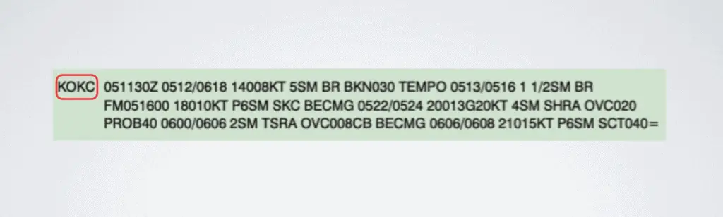
This first section is for the KOKC airport identifier, like I said before. Those four letters are just associated with an actual airport or a station identifier. Each airport has its own four-letter code and that’s the four-letter code for the airport in this question.
Before we actually get to the meat of this TAF, when learning how to read TAFs and METARs it’s important to know that when different weather conditions are being reported in a TAFF the way that it’s going to be laid out is always going to be the same order.
- the date and time that the TAF is valid
- wind direction and speed
- visibility
- anything related to a specific weather condition and
- then anything dealing with clouds
Sometimes any one of those pieces of information can be taken out but when they’re all seen together, they always come in that order. I don’t have a special acronym for that but it is helpful to remember starting out.
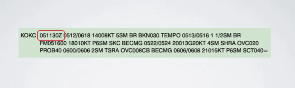
This first section of numbers and letters indicates when the TAF becomes valid. The first two numbers indicate the date. So on the fifth starting at 11:30 Zulu time, this TAF will be valid.
Zulu stands for universal coordinated time and it’s based off of the zero prime meridian line in Greenwich England. This time zone is called Zulu time and it is the standard time that is used in aviation. When you see METARs and TAFs, they’ll always be measured in Zulu time so it’s important to know that. Keep in mind th0ugh that Zulu time is not necessarily your local time. In fact it’s probably not your local time (unless you live near Greenwich, England) so it’s important to know that Zulu time is different than your local time.
For our purposes here we don’t really need to know what Zulu time is in relation to what time zone you’re in, it’s just important to know that the Zulu time is used and that some of these indications will show times and dates. They’re all in Zulu time.
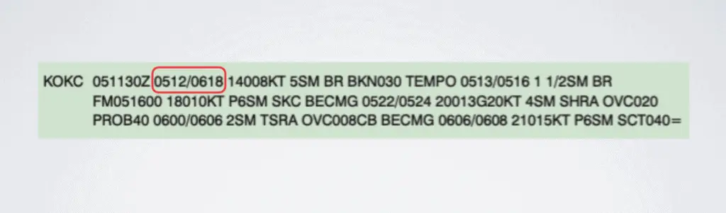
This next section indicates that the weather conditions following are valid on the 5th from 1200 Zulu to the 6th at 1800 Zulu. This is where you’ll start seeing the pattern that I mentioned above (wind direction and speed, visibility, specific weather conditions, cloud layers).
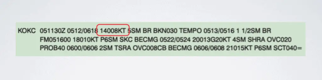
This section is wind direction and speed. The first three numbers are the wind direction, so its saying there’s a wind direction of 140 degrees. 08 indicates the wind speed. So it’s wind in the direction of 140 degrees at 8 knots.
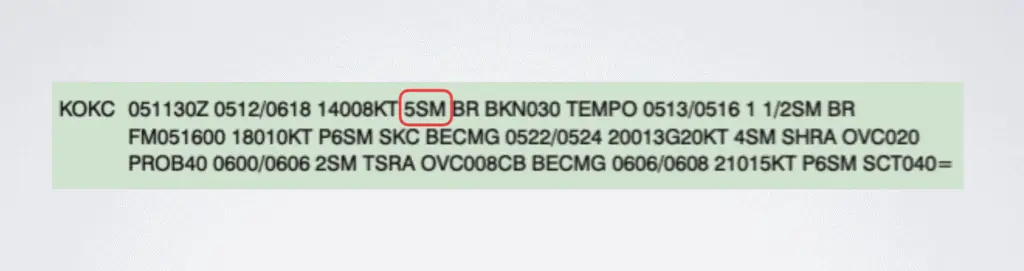
Next, this section indicates 5 statute miles of visibility.
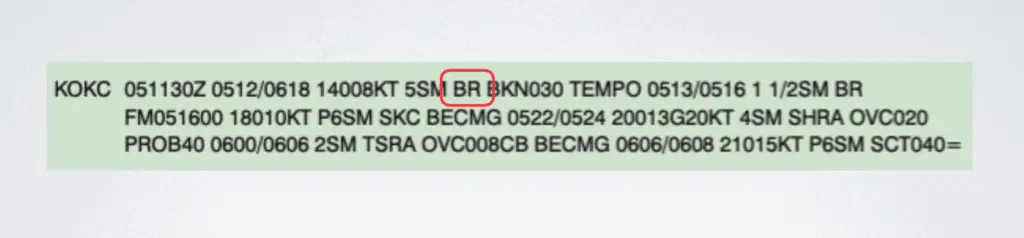
BR is the specific weather conditions for this time period and means there will be mist. This is one of those abbreviations that just makes you scratch your head. I don’t know who came up with it but BR is the abbreviation for mist.
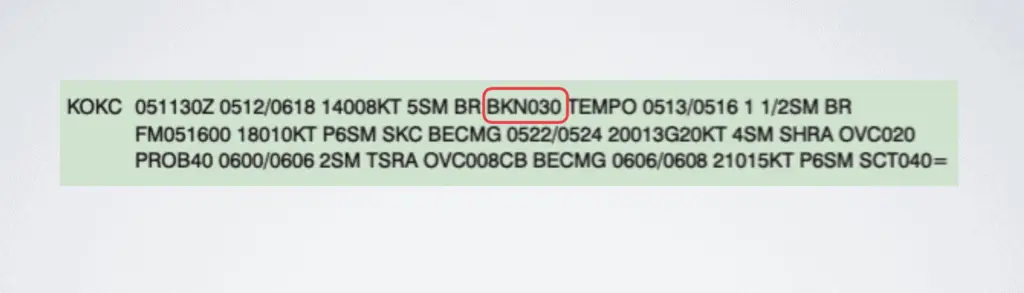
The next part of the description is talking about the clouds and it’s saying that there is a broken layer of clouds at 3,000 feet. You know that it’s 3,000 feet because it says 030 and whenever you’re reading the cloud layers you knock off the last two zeros. If I were to add two zeros back on, it would be 3.000 feet.
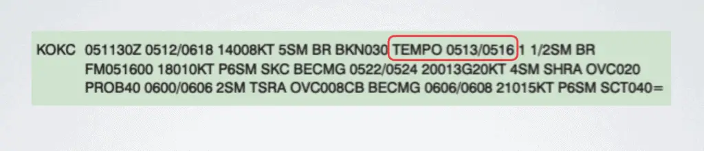
Tempo means that there’s a weather condition that’s quickly changing. So, for the time period from the 5th at 1300 Zulu to the 5th at 1600 Zulu, the expectation is the conditions that follow.
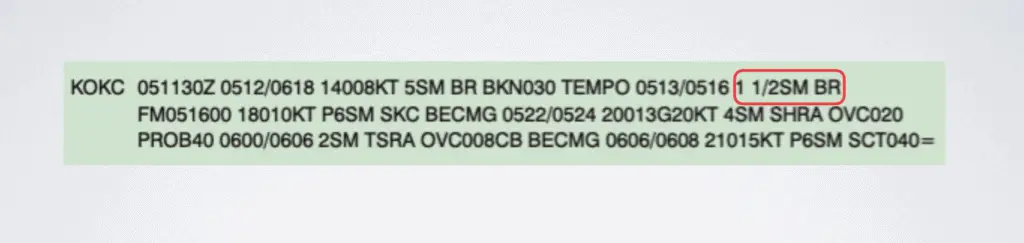
Again, we see SM for statute miles, so we know that it’s a mile and a half statute miles of visibility. We also see the BR again, so we know there will be mist. Remember, this is still following that same pattern of visibility then specific weather conditions.
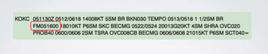
The next set of letters and numbers indicates that from (FM) the 5th at 1600 Zulu, you can expect the following conditions.
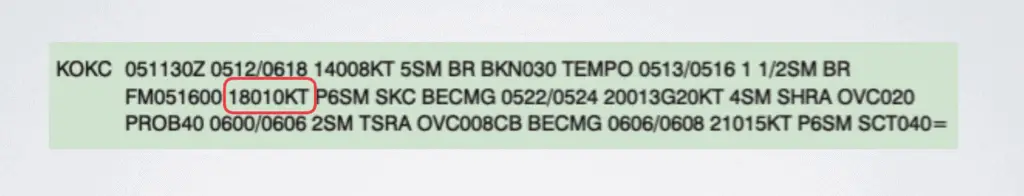
Again, we’re following that same pattern starts with wind direction and speed. Wind direction is at 180 degrees, which is directly South at 10 knots.
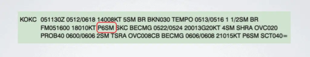
Next, we’re going to visibility again. The P in front of this just indicates that it’s the greatest that it can be. The most you would see is 6 statute miles of visibility. So, this is saying that there is more than 6 statute miles of visibility.
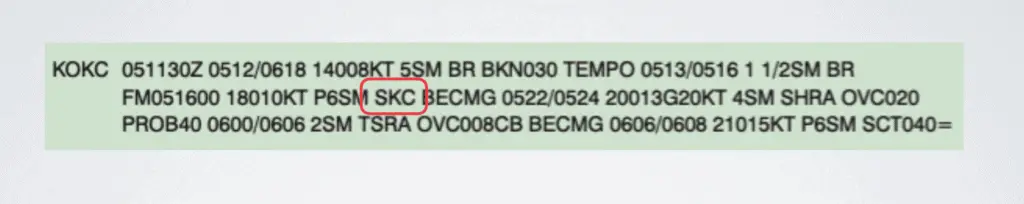
The SKC indicates that there are clear skies, which is a condition related to the visibility. Remember though that the question mentioned something about clear skies becoming something else. So seeing SKC should make your think we’re coming up on the part of the TAF that matters for this question.
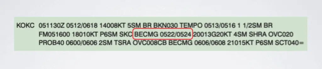
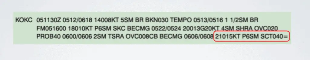
Then we’re back to a specific date and time period where it says that on the 5th at 2200 Zulu to the 5th at 2400 Zulu is it becoming (BECMG) the following conditions.
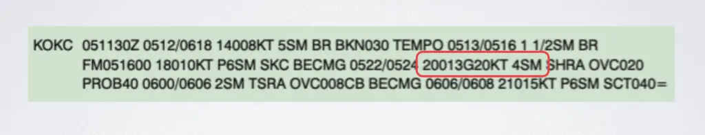
Following the same pattern, we then go to wind speed and direction and then visibility. So the wind direction is 200 degrees. The G here stands for gusts, meaning that the wind is 13 knots gusting at 20 knots. Following that is the visibility which is 4 statute miles.
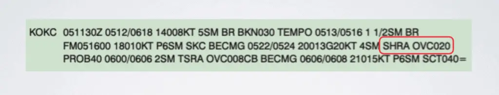
Then you have a specific weather condition. The SH means that there are showers and the RA means rain. Then you’re getting the cloud description again. There’s an overcast layer at 020, which is 2,000 feet because you drop off the last two zeros.
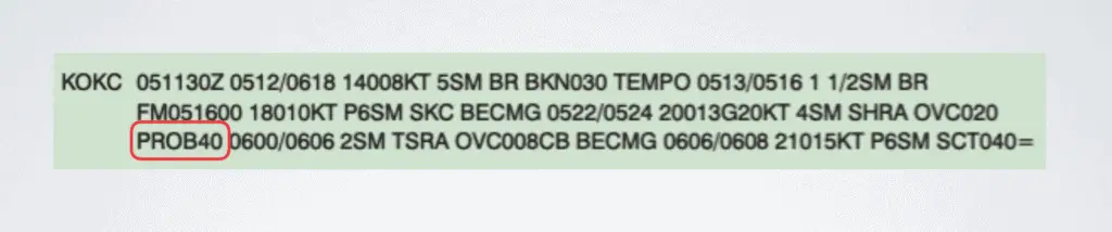
Then PROB40 means that there’s a probability of 40% that the following conditions will apply.
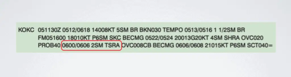
Those conditions will apply starting at midnight on the 6th going to 600 Zulu on the 6th. You’re going to have 2 statute miles of visibility. After that it’s describing a specific weather condition where the TS stands for thunderstorms and the RA stands for rain.
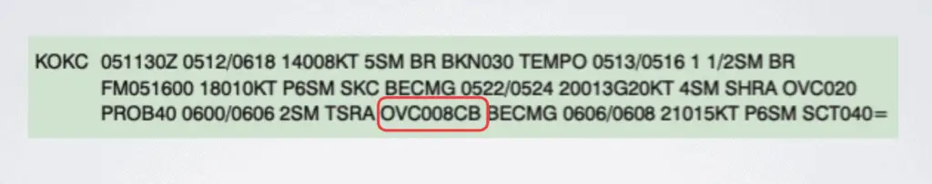
Then you’re dealing with the clouds again where it is overcast (OVC) at 800 feet because you drop off the last two zeros. Since there are no zeros behind the 8, it is 800 feet. The CB at the end is an indication that the clouds will be cumulonimbus clouds, which are typically associated with thunderstorms.
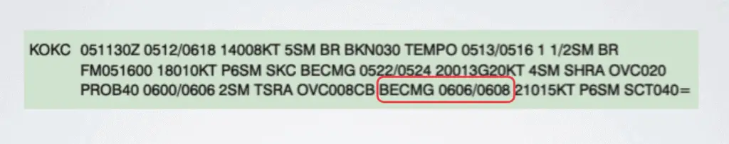
Then we’re going back to another time period again becoming on the 6th at 600 Zulu to the 6th at 800 Zulu it is becoming (BECMG) the following conditions.
Using the same pattern, we’re starting out with the wind direction and speed. The wind direction is at 210 degrees at 15 knots. You have greater than 6 statute miles of visibility. Then we’re moving on to the clouds, where there’s an indication that it is scattered at 4,000 feet. Remember, we drop off those last two zeros to know that it’s 4,000 feet. The equal sign at the end is really just an indication that that’s the end of the TAF for KOKC. Typically when TAFs are put together there are multiple station identifiers together at once. This is just a way to indicate the end of one and the start of the next.
I know that this is a lot to process and I know some of the abbreviations don’t make much sense. Here’s a link that gives you all the abbreviations you will find in a METAR and TAF. Also, here’s a tool where you can cut and paste a METAR or TAF onto the website and it’ll give you the reading.
Now, we’re going to go back to the question, which will really help you apply the information we’ve been covering on how to read TAFs and METARs
In the TAF from KOKC, the clear sky becomes:
- Overcast at 2,000 feet during the forecast period between 2200Z and 2400Z
- Overcast at 200 feet with the probability of becoming overcast at 400 feet during the forecast period between 2200Z and 2400Z.
- Overcast at 200 feet with a 40% probability of becoming overcast at 600 feet during the forecast period between 2200Z and 2400Z.
All three of the answers deal with 2200 Zulu to 2400 Zulu.
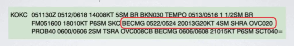
I’ve circled the portion at the top that deals with 2200 Zulu to 2400 Zulu. Remember, where it says BECMG 0522 that means starting at the period of the 5th at 2200 Zulu from the to the fifth at 2400 it will become the following condition.
Let’s start at the last answer and use a process of elimination to go through each of the answers. The last answer says that there’s an overcast layer at 200 feet but if we go to the end of this this section that deals with the right time period it says OVC020. We know that you drop off the last two zeros and that says there’s an overcast layer at 2000 feet. So, this third answer is wrong. It’s also wrong because the only place we see that this TAF talks about a probability of 40% is actually for the next time period (on the third line you’ll see PROB40). Those are the two reasons that that third answer is incorrect.
The second answer also says that there’s an overcast layer at 200 feet so we can mark that one out for the same reason as the third answer. The TAF doesn’t say that there’s an overcast layer at 200 feet but it also doesn’t say that there it will become an overcast layer at 400 feet. Those are the two reasons that I would mark out the second answer.
That means the first answer is correct and like I’ve been saying all along that’s what OVC 020 means, an overcast layer at 2,000 feet. Remember, you knock off those last two zeros.