

I’ve got another FAA Part 107 test question today. This one is going to be super helpful because it is the type of determination that you will be required to make when you are actually flying your drone for money. Don’t discount the identification of airspace you will be flying in.
Identification of Airspace on Sectionals
Here’s the question:
You have been asked to fly a property for a local real estate agent in the area shown below where the map says “tank farm” (near the number 1 in a red circle). Based on the map below, if you stay below 400 feet above ground level during your flight, what airspace will you be flying in and do you need airspace authorization prior to your flight.
- Class G airspace, no airspace authorization needed
- Class D airspace, prior airspace authorization needed
- Class E airspace, prior airspace authorization needed
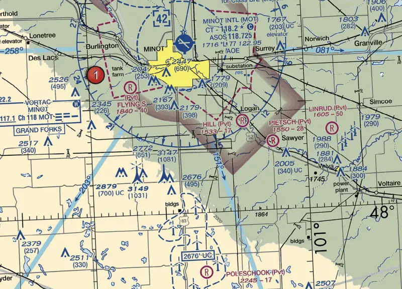
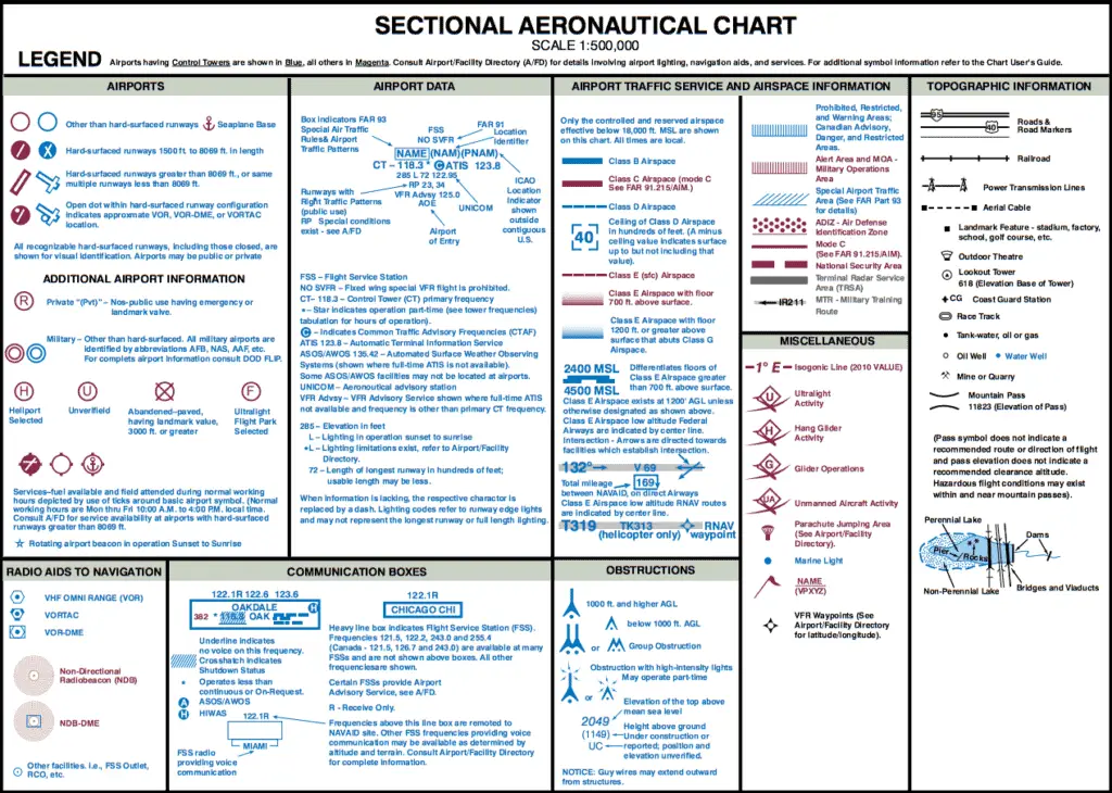
Let’s start with a quick review of the sectional legend (which you should always do when you get a sectional question on the test). The airspace information section of the sectional legend shows that a dashed magenta line means “Class E (sfc) Airspace,” while the faded magenta line means “Class E Airspace with floor 700 feet above surface.”
So, the real question is, which of these lines surrounds the area you’ve been asked to fly? Let’s go back to the map.
You’ve been asked to fly where the map says “tank farm” and this area is underneath a dashed magenta line. That means Class E airspace extends to the surface, just like the sectional legend states. Because Class E airspace is controlled airspace, you will need authorization.
Covering the Wrong Answers
To cover the other two answers, if you were to fly within the faded magenta area on the map, Class E airspace would only extend down to 700 feet above the ground, meaning that you’d still be in Class G airspace up to your 400 foot limit and would not need an airspace authorization.
Likewise, if you were flying within the dashed blue line on the map, this is Class D airspace from the ground up to 4,200 feet MSL, so you would also need airspace authorization here.
Real Life Application for the Identification of Airspace
This question is a great primer for something you’d actually see in real life. It is important to know the airspace around the airports near you so that you can be confident when a client asks you to fly at a specific location. At a minimum, you’ll want to ask yourself
- What type of airspace will I be flying in?
- Can I get an authorization through LAANC?
- If not, can I submit an airspace authorization through the drone zone (and get approval) before I need to fly this flight?
Once you know you either don’t need airspace authorization or can get it before your flight, you can confidently inform your client that you can fly their property.
Although the FAA has rolled out the LAANC system to airports nationwide, you should know that this doesn’t mean every airport has started using LAANC so it may not be available at your local airport. It is important to know this and check for any flight restrictions before scheduling a flight.
Finally, if you need to get an airspace authorization (check out my article on airspace authorization), you are able to to schedule LAANC approval up to 90 days in advance. I’ve only found this feature slightly useful since LAANC approval is immediate and has become part of my workflow at the location. But if you’re a hyper planner and you know that you’ll be at the site to fly exactly when you schedule the flight, this might be a great option for you.
If you’ve made it this far and this article was helpful to you, I put out new content all the time and would love to be invited into your inbox. I hate emails that clutter my inbox, so I won’t clutter yours. Just helpful information about flying your drone legally. Sign up below if you’re interested.