

Okay, we’re doing another Part 107 test prep question of the week. This week we are looking at obstacles on sectional charts. So, here is a small piece of a sectional chart with obstacles on it and the question is below. Or you can just watch the video.
Part 107 Test Question
In the figure below, there’s an obstacle just to the south of the Morehead Rowan County Thomas Regional Airport. What is the height of that obstacle above ground level or AGL?
- 350 feet
- 1,355 feet
- 404 feet
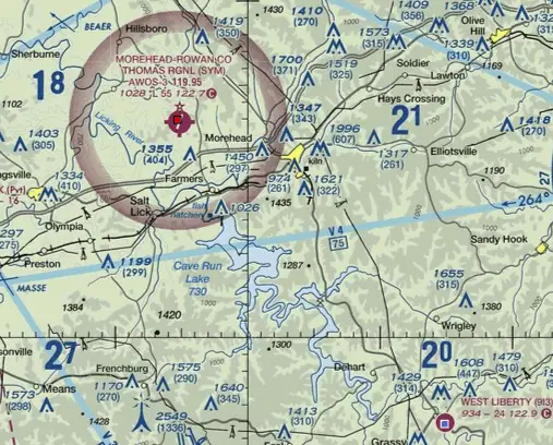
Okay, so it’s not 350 feet. While there is an obstacle just to the north of the airport that is250 feet above ground level, this is not the one we are looking at in this question.
It’s also not 1,355 feet because the obstacle to the south. If you look at the “1355” right next to the obstacle, this number indicates that the peak of the obstacle is at 1,355 feet mean sea level.
That means 404 feet is the correct answer. When it comes to dealing with obstacles on sectional charts, the number in parenthesis is the one that indicates the height above ground level or AGL.
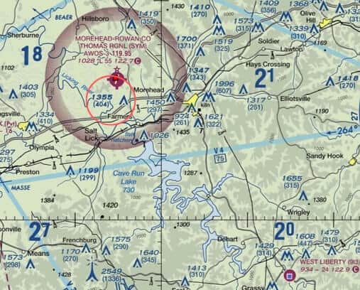
Other Obstacles on Sectional Charts
If you look even further over to the west (circled in the picture below), there’s a group of obstacles it almost looks like an M with two dots underneath it. This indicates that there are a group of obstacles and the 1334 indicates the height in mean sea level. But in parentheses, there’s the number 410, which is the height above ground level. You’re not always going to have the number in parentheses underneath but for a lot of them you will and when you do it indicates above ground level.
Related: How to Read a Sectional Chart
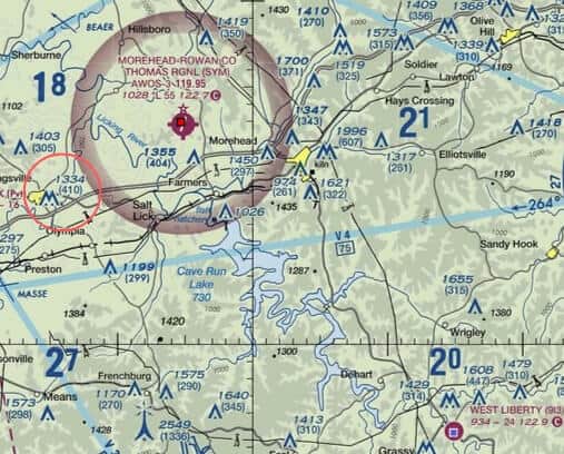
Just a sort of a bonus tip, when the obstacles on sectional charts show up in the “A” shape that means it’s one obstacle and it means that the obstacle sticks up less than 1,000 above ground level.
When the obstacles on sectional charts show up in the “M” shape, like the one that says 1331 next to it, that indicates that it’s a group of obstacles but again it’s still going to be less than 1,000 feet above ground level.
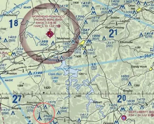
If you look even further to the south in the picture, just outside of Moorhead’s airspace down near Frenchburg, there is an obstacle that looks more like a tower that has sparks coming out of it. That actually means that it’s a lit obstacle and when it’s that tower shape, the one that looks more like a like a cell tower or something like that, that indicates that it’s more than 1,000 feet above ground level. So these are just larger obstacles.
If you’ve made it this far and this article was helpful to you, I put out new content all the time and would love to be invited into your inbox. I hate emails that clutter my inbox, so I won’t clutter yours. Just helpful information about flying your drone legally. Sign up below if you’re interested.