

Okay, so today we’ve got another FAA part 107 test question video walkthrough. This week we are dealing with latitude and longitude. This continues to be a subject that causes a lot of confusion for new drone pilots. This is especially true if you don’t have an aviation background.
Longitude and longitude isn’t exactly intuitive and so sometimes it takes a little bit of work to figure this one out. I’ve also got a whole article on understanding longitude and latitude.
The video is below and the rest of this article kind of tracks with the video, which just walks through the Part 107 test question.
The question this week is:
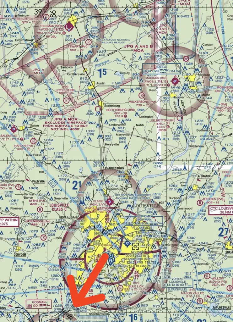
What is the approximate latitude and longitude of the little York Airport in the figure below?
- 38° 12’ N – 86°05’ W
- 38° 42’ N – 85°55’ W
- 39° 12’ N – 85°55’ W
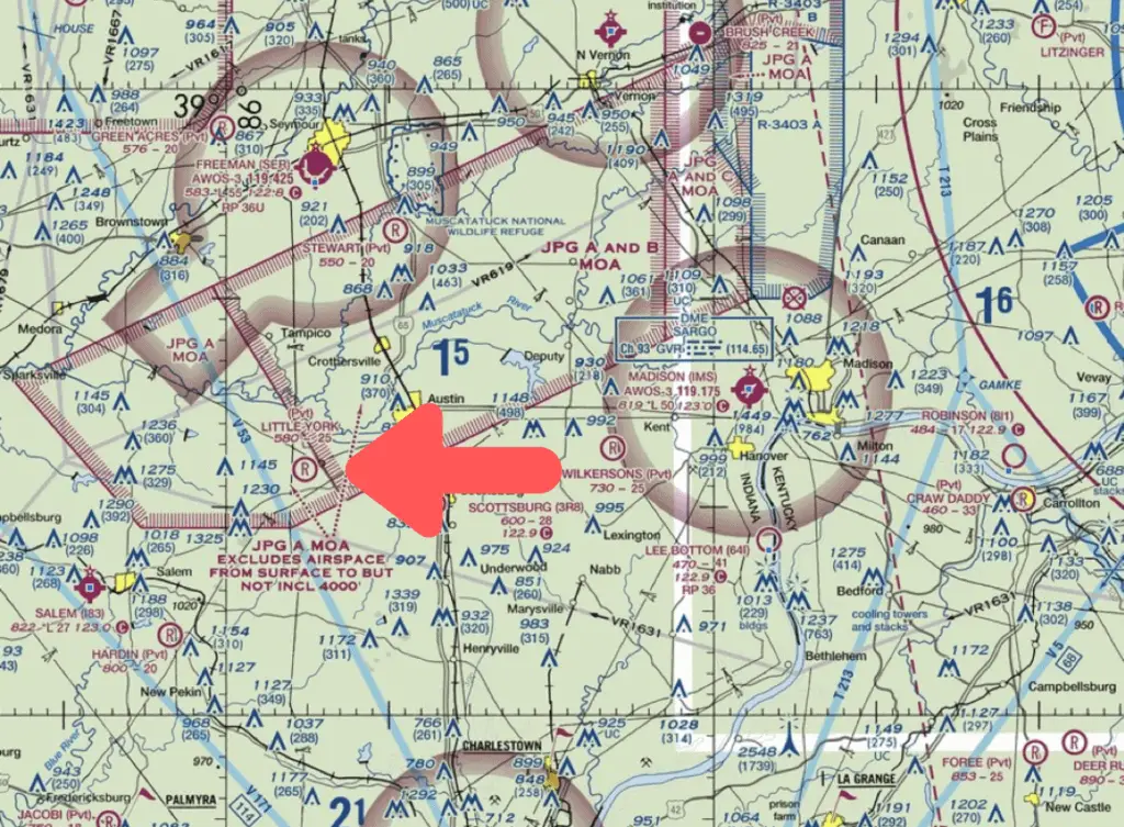
Above is a zoomed out picture of the airport with an arrow pointing to the York airport.
Most Important Latitude and Longitude Lesson
First and foremost, the most important thing to remember about latitude and longitude is:
1. The Equator is a line of latitude and we know that the Equator represents 0 degrees latitude. It is helpful to think about the lines of latitude like the rungs on a ladder and you should recognize that each of the lines of latitude runs east to west. See the picture below for a visualization.
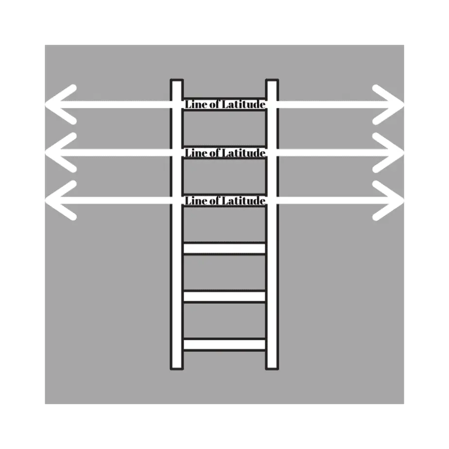
2. The Prime Meridian in Greenwich, England represents zero degrees longitude because lines of longitude run along the side of the earth. This means that lines of longitude run north and south.
Understanding Longitude and Latitude Generally
Here, the 39 degree line of latitude that we see north of the airport will continue to increase as we go North because this is farther from the Equator (at zero degrees). So the further south you go, the smaller the latitude numbers are going to get because you are moving closer to the Equator.
The same with lines of longitude. The Prime Meridian in Greenwich, England is the zero degree line of longitude and we know that the United States is further west of England so the further west we go, the larger the numbers will get.
Here, there’s also the 86 degree line of longitude in the picture, so those are the two prevalent markings that we have on this part of the sectional.
Figuring Out Longitude and Latitude
This means that because the airport is south of the 39 degree latitude line, we know that it can’t be anything higher than 39 degrees. That means answer 3 cannot be correct.
We can do the same thing with the the lines of longitude we know that it is east of the 86th degree of longitude, so we know that it has to be something less than 86 degrees. That means answer 1 is wrong because the airport is not more than 86 degrees in longitude.
Understanding the Correct Answer
Now that we know what the correct answer is, let’s figure out why it is correct. By the way though, using this process of elimination is a great way to work towards the correct answer on the test. Any time you can logically take a question apart in order to eliminate wrong answers, it will be helpful.
As helpful as that is, it’s probably more important to have a good understanding of why this answer is actually correct as opposed to why the other two answers are incorrect so we’re going to go into a little bit more detail here.
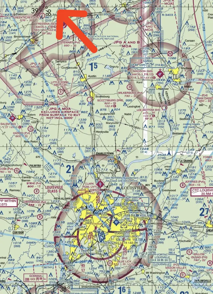
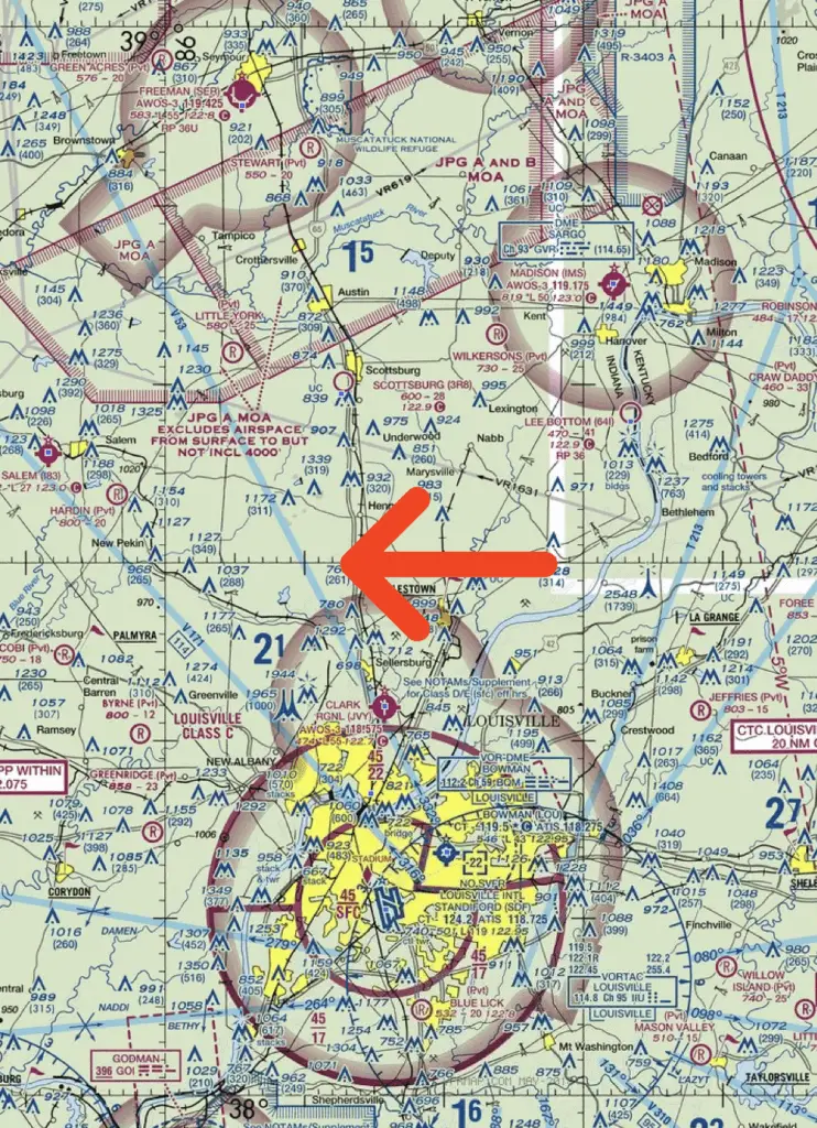
If you look at the picture above, the arrow is pointing to the 39th degree of latitude.
If you look at this picture above, the arrow is pointing to the 38th degree line of latitude.
But you’ll also recognize in the picture above that marks the halfway point between 38 degrees and 39 degrees latitude so the halfway point. If you think about each degree of latitude being like an hour there are 60 minutes in an hour and the halfway point in between (the arrow above) will mark 30 minutes.
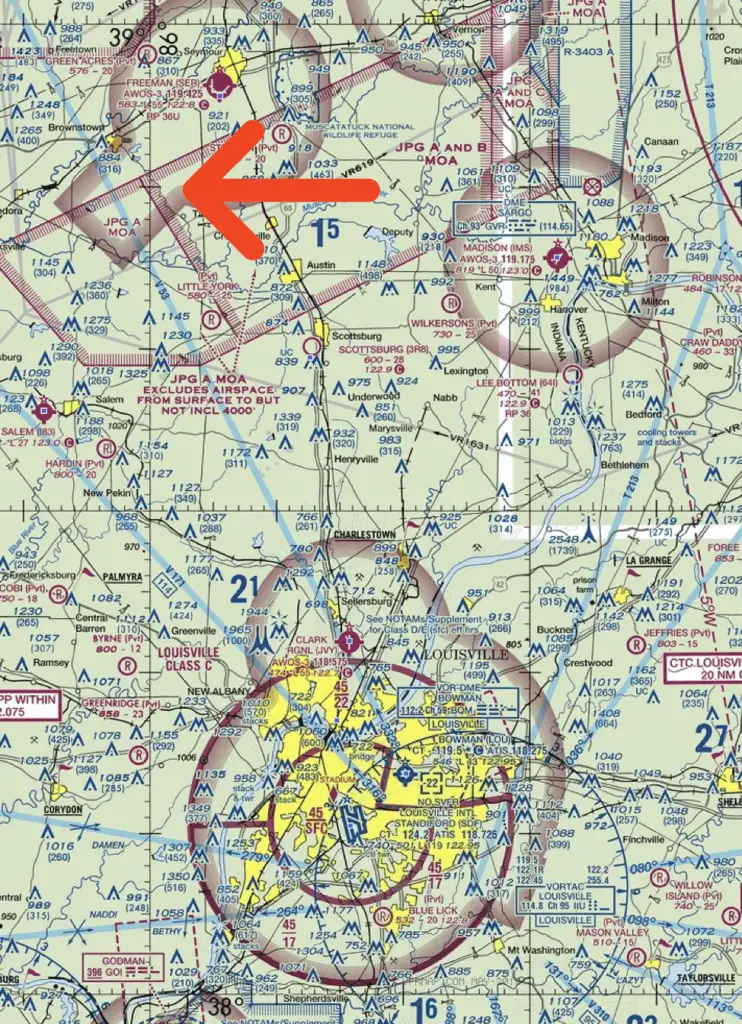
Each of the lines that is a larger hash mark, where the arrow is pointing in the above picture is going to be ten degrees. So, if you look at the 38 degree of latitude then you go halfway up you have 38 degrees and thirty minutes then you go up another 10 degrees that’s 38 degrees and 40 minutes so that places the little York Airport right above that at 38 degrees and roughly 42 minutes.
Now, we’re going to do the same thing for the lines of longitude as well.
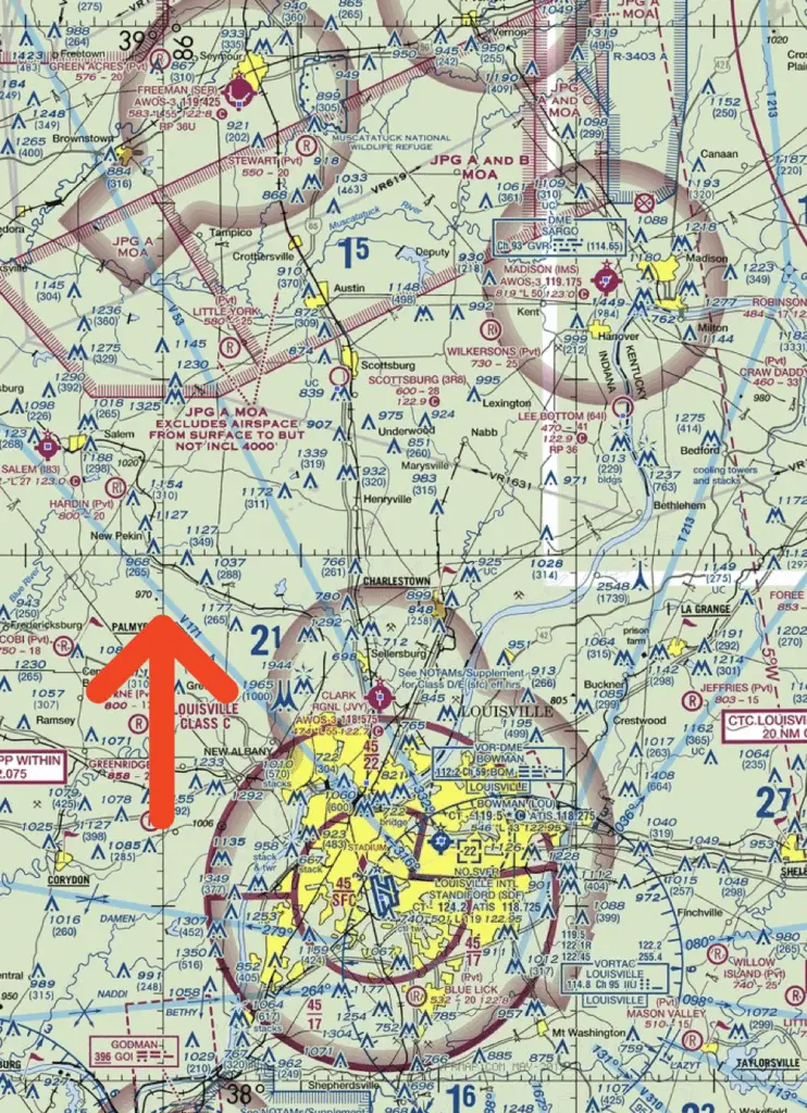
First, the arrow in the picture above points to the 86 degree line of longitude. Then if we look to the right, there’s another 10 minute mark, which is 85 degrees and 50 minutes. From there, you just extrapolate between those two markings to find that the little York Airport is at roughly 85 degrees and 55 minutes of longitude. If you go back to our answer, that’s what we figured out was that it was 38 degrees and 42 minutes north latitude and 85 degrees 55 minutes west longitude.
I hope this Part 107 test question video walkthrough was helpful. If you want to take a full Part 107 practice test, I’ve got one available for free here.
If you’d like weekly test question walkthroughs like this one sent directly to you inbox, sign up below! This is a really easy way to stay current on your Part 107 knowledge without spending hours right before the test.