

Today we are looking at a Part 107 test question that will help you understand how to read a sectional chart. (Just a reminder that we have a whole article on how to read a sectional chart, specifically designed for drone pilots).
This article will cover the same Part 107 test question as the video below. Feel free to watch the video or just read the article.
Okay, so let’s get right into it. This Part 107 test question will help you understand how to read a sectional. Specifically, we’re going to walk through how I would go about answering this question.
(Refer to Figure 20.) Why would the small flag at Lake Drummond in area 2 of the sectional chart be important to a Remote PIC?
A. The flag indicates a GPS check point that can be used by both manned and remote pilots for orientation.
B. The flag indicates a VFR checkpoint for manned aircraft, and a higher volume of air traffic should be expected there.
C. The flag indicates that there will be a large obstruction depicted on the next printing of the chart.
After reading this, what I would do is refer over to figure 20 and find area 2, which includes the flag that is located at Lake Drummond on the map. Here is the image you would be reviewing:
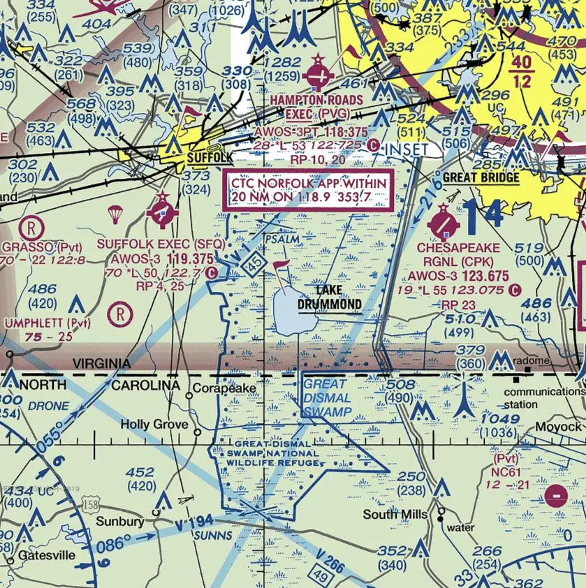
You’ll see right in the middle is Lake Drummond and there is the flag that it’s talking about, sticking out at the top.
Once I saw this I’d probably flip over to the sectional legend to see if I can find a picture of the flag itself and see what the legend says about that image. I’m looking for anything that tells me about what it means.
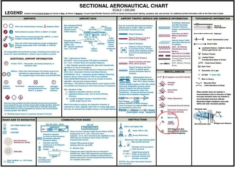
So here, although as you can see in the small red circle it does show the flag, it doesn’t really give us too much information about what the flag itself means.
It’s located under the miscellaneous section that’s not really that helpful.
And it really just shows you a picture of the flag and then indicates that the flag self would have some sort of name out from it.
So at this point I would probably flip back over to the question and I would reread the answers.
The first option says “the flag indicates a GPS checkpoint” and while that’s probably true I think I’d be a little bit skeptical of the fact that it’s a GPS checkpoint because the map we’re looking at is a VFR sectional. VFR stands for “visual flight rules” so it’s a visual flight rules sectional or some sort of a sectional chart or a map that a manned pilot would be using when they’re flying using visual flight rules. I’m not really sure that I would understand why it being a GPS checkpoint is helpful when the rest of the map doesn’t really provide a lot of GPS related information.
The other thing I don’t like about this option is that while the checkpoint could be used by both manned and remote pilots sectional charts and the information that they provide are typically geared more towards manned pilots and not remote pilots and I know this is a really fine distinction but that’s the other reason I wouldn’t like this answer.
We’re going to skip over the second choice for just a second and come back to it after we review the last choice.
The last choice says that the flag says:
C. The flag indicates that there will be a large obstruction depicted on the next printing of the chart.
But we already know that large obstructions typically have their own symbol or set of symbols and so I would flip back to the sectional chart and see that there’s a whole section of obstructions.
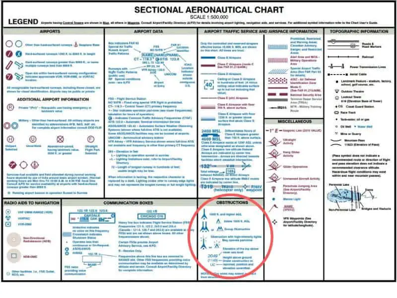
So having a flag that would indicate a future obstruction wouldn’t really make much sense, especially since all of the symbols for obstructions actually show altitude or height or grouping or specific things about the obstruction.
Here we don’t have anything like that. The flag is over top of a lake and it just has the name of the lake. That’s all it provides us. It doesn’t provide us any altitude or height or indication of how high the future obstruction will be or anything like that. So that’s why I wouldn’t like that third answer.
The second choice says
B. The flag indicates a VFR checkpoint for manned aircraft, and a higher volume of air traffic should be expected there.
That one seems accurate because like I said before, this map is a VFR sectional. So a VFR checkpoint would make sense.
It would also make sense that something like a lake would be a checkpoint for a manned aircraft because they’re going to be using ground references for points of reference when they’re flying.
So, that’s the logic I would probably walk through with this question. I would end up doing away with the last option and the first option and that would obviously leave us with answer B and this is our correct answer.