Geofencing on drones is a way for drone manufacturers to make sure that drone pilots aren’t flying in areas that have been marked as off limits. DJI uses a system called the Fly Safe System, which restricts flight in certain areas but also allows for you to unlock for authorized flight.
I live in an area that is covered by the airspace for a pretty big international airport, so I’ve had the opportunity to become pretty well acquainted with how geofencing works on drones, specifically DJI’s Fly Safe System. You know, like every time I fly at my house. I live in an area that allows authorization, so it is not much of a hassle at all.
What is the DJI Fly Safe System?
Like I mentioned above, the DJI Fly Safe System uses the GPS signal on your drone to determine your location. We all know this is the case because its just a given that you will use GPS lock to fly your drone without drifting. Obviously then, DJI is able to create areas that do not permit drone flight or require authorization before a drone flight can happen. This system is automatically implemented and used when you upgrade the firmware on your drone and the app on your phone or tablet.
While this is a fantastic use of technology to enhance safety, a common complaint about the Fly Safe System is that can clutter up the map to the point where you can’t even see anything. Like this:
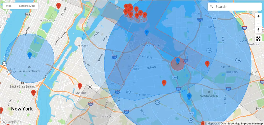
Check out DJI’s Geo Zone Map for yourself here.
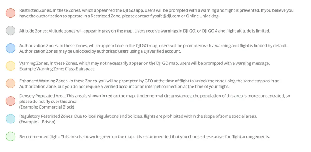
What do all the colors mean?
DJI’s website provides the following breakdown of the colors, which ay or may not be helpful. I’ll provide a better understanding of each of these below.
DJI Restricted Zones
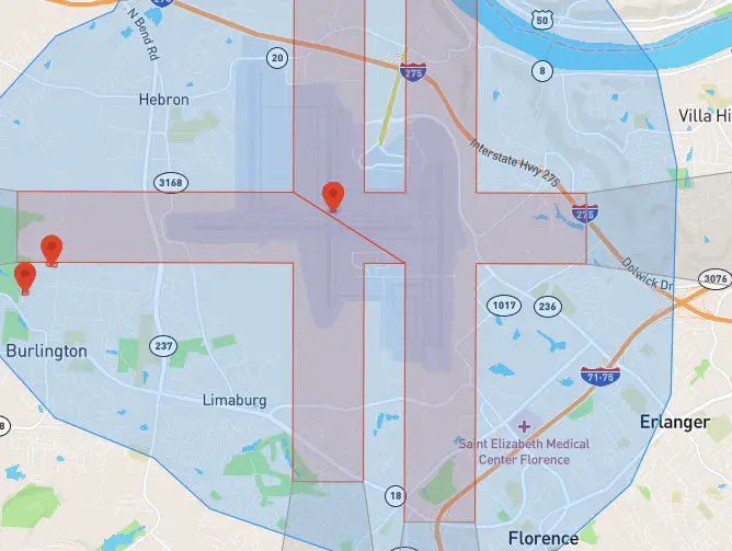
If you look at most airports, the restricted zone will be overlaid on the actual runways. It makes sense that you wouldn’t be able to fly here. The picture below shows Cincinnati International airport on the DJI Fly Safe Map. The red blocks are restricted zones.
And this picture shows the FAA’s approval map via LAANC. As you can see, the 0 grid areas pretty much mirror DJI’s restricted area.

There are definitely other places that a restricted zone would show up, but this is one of the most common. You are able to unlock a “restricted area” in the DJI app, but you have to go through a little bit of a process to do it. I’ve never personally had to fly in an area like this, so I don’t have experience with this process, but here’s a video from DJI explaining the process.
DJI Altitude Zones
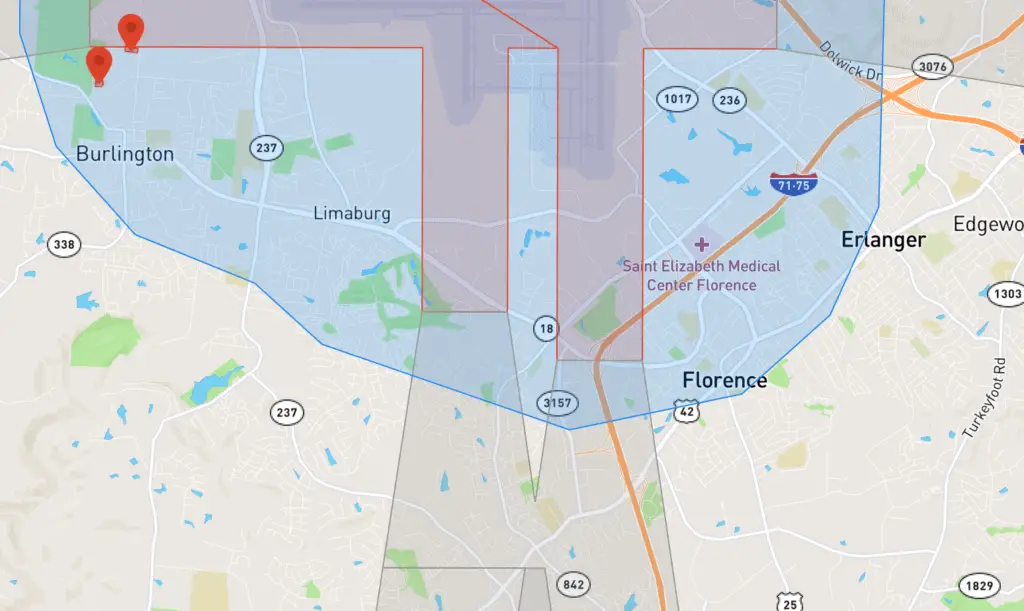
The best example an altitude zone would be the areas where aircraft fly their approaches or departures from an airport. In my experience, these don’t cause any problems. You don’t need approval, and a lot of time they aren’t even in controlled airspace. These are really just an extra guard against rogue drones. I do believe your drone’s altitude is automatically capped but I’ve never tested it because the altitude cap is likely at or above where you can legally fly anyway. The grey blocks extending outward from the runways in the picture below are altitude zones.
DJI Authorization Zones
These are probably the zones that you will run into the most, as these are the zones surrounding most airports. Again, these tend to mirror the FAA’s grid map for LAANS approval. Getting access to fly in an authorization zone is actually pretty easy. You just need a verified DJI account, which you should have as long as you’re logged in on your DJI Go app. The that I included above also covers how to fly in authorization zones.
DJI Warning Zones
I went out of my way to find a good example of a warning zone, but couldn’t find one. The legend on DJI’s website says that Class E airspace should show up as a warning zone but I looked at a few Class E airports and there was no warning zone. No matter, this one would just be informing you of airspace, but would not be any area that would require any kind of permission or authorization on your part.
DJI Enhanced Warning Zones
I also could not find any of these. It’s not entirely clear what separates a warning zone from an enhanced warning zone but it looks like this one would require you to bypass the warning but does not even require an authenticated DJI account. Again, I couldn’t find an example of this but it does not appear to include prohibited flight areas, as these would likely fall under a “restricted zone.”
DJI Densely Populated Area
I’m near a lot of pretty densely populated areas and I’ve never once seen this notification pop up. It seems to me that maybe DJI’s Geofence legend needs updated. I’m not even sure that they use all of the colors anymore. That said, if you see orange (which seems easily confused with the orange for a “restricted zone”), do not fly over this area.
DJI Regulatory Restricted Zones
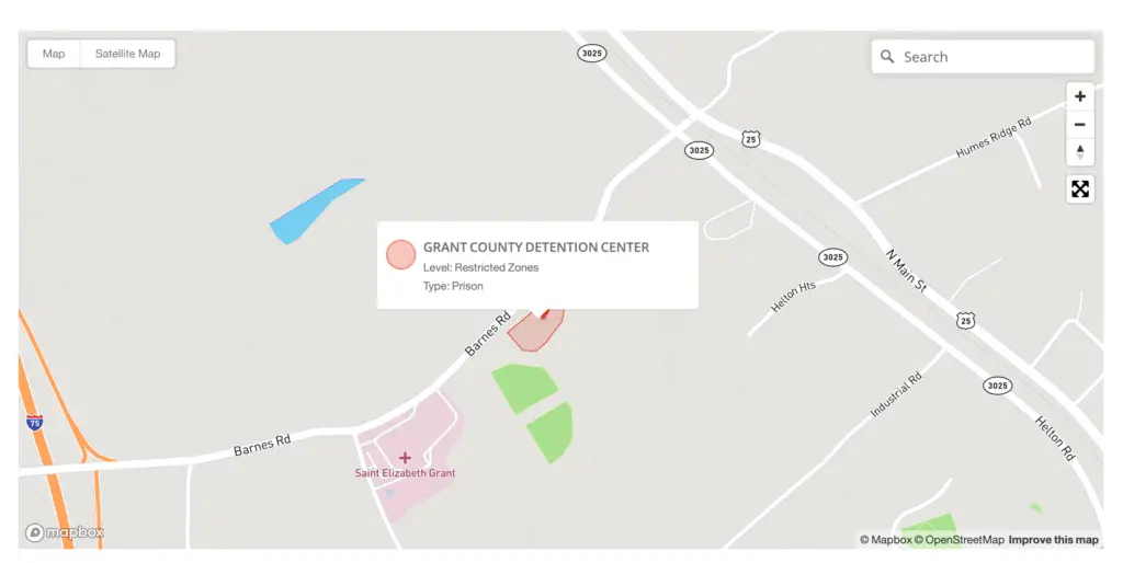
The DJI legend says that this color would include “prisons” but I looked up the prison pictured below, and it shows up as a “restricted zone.” Logistically, I’m not sure it makes much of a difference and I would treat anything is a “regulatory restricted area” the same as I would a restricted area.
DJI Recommended Flight Zones
I looked for one of these on the map and couldn’t find a recommended flight zone. This might include something like a flight park for model aircraft but like I said, I was unable to find one of these. It seems to me that the lack of some other color means that it is “recommended” because it isn’t restricted in any way. Feel free to let me know if you’ve ever come across this type of flight zone in the DJI Go app.
So, where can I fly my drone?
Understanding how geofencing works on drones is pretty important these days. Like I mentioned above, if the area you are flying in is not within a color block, you should be good to fly. One caveat is that there are a few places where it looks like DJI’s restrictions are less strict than the FAA rules, so you should also be using a LAANC app to make sure the area you’re flying in does not require FAA authorization. Just to recap:
- You are not allowed to fly in restricted zones, densely populated areas or regulatory restricted zones. Despite this, there is a process you can go through to get an unlock in restricted zones.
- You will need authorization (LAANC or airspace authorization) and a verified DJI account to fly in authorization or enhanced warning areas
- Flight is limited in altitude zones
- Flight is not restricted at all in warning zones or recommended flight areas.
Self-Unlocking the DJI Fly Safe System
The good news is that you are able to unlock and fly your drone even when DJI’s Fly Safe System initially restricts you from doing so. There are perfectly legitimate reasons to do so, including times when you have permission from the FAA to fly in controlled airspace.
To do this, you have three options, depending on the use. The first is called Live-Self-Unlocking, and can only be used if the DJI Go app is connected to the internet. When the flight restriction appears, hit the “yes” button and verify your account via either a credit card or your phone. Once verified, hit the “confirm” button to unlock the authorization zone.
The second option is to navigate to DJI’s website and login (link to DJI self unlock). Once you’re here, you will navigate through the page, requesting a zone to unlock and providing a period of time that you’d like the area to be unlocked. You will need your flight controller’s serial number. You can find this in the DJI GO app in General Settings> About.
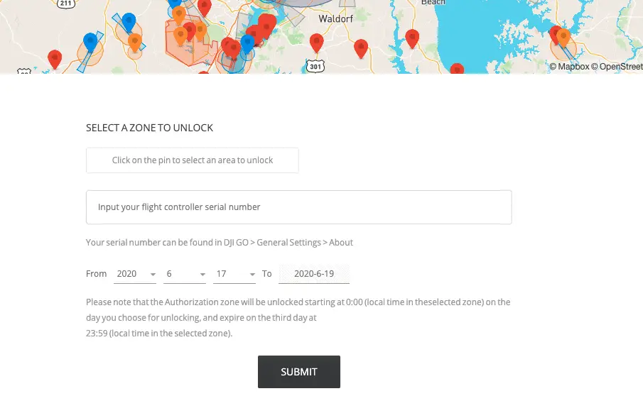
The rest of the confirmation process is similar to the Live version above, using the app. You will again have to choose a credit card or phone for verification.
There is also a third option that you will need to use when trying to fly in a “Restricted Zone.” This includes controlled airspace. To do this, you will navigate to the DJI website again and go largely through the same steps as above, except that you will now need to enter your FAA authorization number. Because of this, if you know you will be flying in controlled airspace, you should apply for a custom unlock a few days prior to the flight to make sure that there aren’t any issues on the day of the flight.
